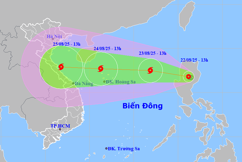
DNO - A tropical depression entered the East Sea last night and is forecasted to strengthen into storm No. 5, according to Vietnam's National Center for Hydro-Meteorological Forecasting.

As of 1:00 am on Saturday, the center of the tropical depression was about 730km east of the Hoang Sa Special Zone. Wind speeds near the tropical depression's center reached level 7 with gusts at level 9.
Forecasters predict that over the next 24 hours, the tropical depression will race westward at 20 - 25 kilometers per hour, gathering strength and potentially evolving into a storm - the fifth one in the East Sea this year.
At 1: 00 am tomorrow morning (August 24), the storm's eye will be in the sea northeast of the Hoang Sa Special Zone. Maximum sustained winds near the storm's center will reach level 9, with gusts up to level 11.
Due to the impact of the storm, the northern and northcentral parts of the East Sea will experience strong winds and rough waves.
Between the night of August 24 and the end of August 27, the coastal localities from Thanh Hoa to Hue are forecast to experience sustained heavy to very heavy rainfall. Rainfall will range from 150mm to 300mm, with localized areas potentially exceeding 600mm.